Cape York Atlas And Guide
The Cape York peninsula is a popular area for 4x4 trips and Hema's great regional map has been the starting point for a lot of fun outings. Anybody heaving north of Cairns will really benefit from clear road and track information, because when it rains up there plenty of the routes get closed pretty quickly. If you're looking at a longer trip, though, Hema have an even better option for you.
The Cape York Atlas & Guide is a handy book in road atlas format, and it includes all the mapping from the Cape York map. On top of that you get even more inset maps showing areas of interest in high detail and a load of other bonus features. The guide includes top tips for where to camp or go fishing, heaps of info about accommodation - everything from classy hotels to awesome bush camping spots - and background on the area's plants and wildlife. It also includes a guide to the top 10 best 4x4 routes written by expert driver Allan Whiting, complete with detailed descriptions of each. Trips include:
- CREB Track
- Palmer River Goldfields
- Cape Melville NP
- Rinyirru (Lakefield) NP
- Mungkan Kandju NP
- Kutini-Payamu (Iron Range) NP
- North of Weipa
- Old Telegraph Track
- East and west of Jardine River
- The Tip
Details:
Size: 215x297mm Spiral bound
Pages: 128
Edition: 3rd
Published: 2012
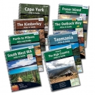 Regional Atlases
The Hema Regional Atlases & Guides offer essential information on a variety of major regions throughout Australia.
Click here to buy Regional Atlases.
Get In Touch
Please use the form below to contact Tough Toys via email.