A Historical Desert Trip - The Oodnadatta Track
Oodnadatta is a small, remote outback town in South Australia. The Oodnadatta Track runs through the town of Oodnadatta and can be reached
from Coober Pedy, Marree to Marla or from the North via Finke Northern Territory.
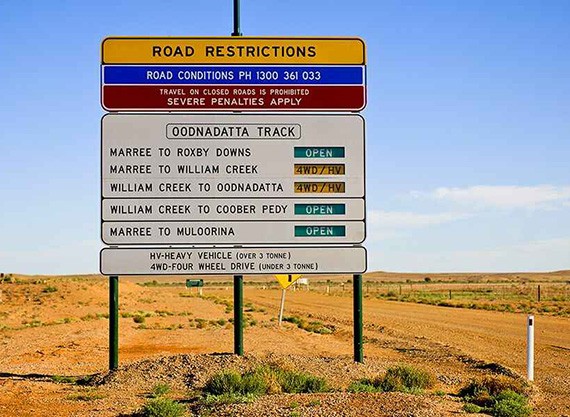
The Oodnadatta Track is a 614km unsealed route known for its red sands, extreme temperatures, historic sights and rugged terrain.
In dry weather, the track is passable to most vehicles and caravans, but a 4 Wheel Drive is essential for driving the track during and
after rain. Since the track is unsealed, the local and state authorities recommends that users of the track check if the track is open
before departure.
April to October is the best time to visit. Allowing approximately 3 days to traverse the track is advised to be able to stop and see the sights and many landmarks along the way.

The Pink Roadhouse is an icon along the 4wd community and provides a great photo opportunity as well as an opportunity for restocking fuel
and food supplies. The roadhouse also provides 24-hour recovery, mechanical and welding services if the worst should happen during your
outback trip. Camping is available at the pink roadhouse or alternatively across the road in the free camp area.

Coward Springs is a 120m borehole completed by the SA government where water from the Great Artesian Basin rose 4.6m above ground. The wetland created its own dynamics as an oasis providing water, food, shelter and breeding areas for a wide range of wildlife.The Borehead was eventually replaced reducing the water flow and subsequently the Coward Springs camping ground built a natural spa imitating the old pool.


The most iconic mound springs are found in Wabma Kadarbu conservation park, 450km down the
Oodnadatta Track. Here you’ll find Thirrka (or Blanche Cup) and Pirdali-nha (or The Bubbler). Unlike the
Main Pool at Witjira National Park, swimming is not allowed at these hot spots.
Kati Chanda - Lake Eyre is Australia’s largest salt lake and contains the lowest natural point at approximately 15 m below
sea level. On the rare occasions that it fills completely, it is the largest lake in Australia covering an area up to 9,500 km2.
The lake takes on a pink hue when saturated, caused by algae.
Kati Thanda–Lake Eyre has been a site for various land speed record attempts on its salt flats when dry and an abundance of
birds such as pelicans and banded stilts are drawn to the lake when filled.
There is a campground at Halligan Bay Point on the shores of the lake. It is an exposed, flat campground with
limited facilities – two toilets and two picnic shelters.

The Algebuckina Bridge is a Victorian era railway bridge in South Australia located about 55 kilometres south-east of the town of
Oodnadatta. The Bridge formed part of a Victoria era railway opening in 1892 and closed in 1981. The Algebucking Bridge standing at 587m
consisting of 19 spans and was the longest bridge in South Australia until 2014. This sight is a popular spot for photos and is worth
stopping for.

While you can traverse the Oodnadatta main track without a permit, some permits are required for the national parks areas for camping and traversing. Day passes are available, though if you plan to visit a few it is recommended to consider a ‘desert parks pass’ available online via the National Parks and Wildlife Service South Australia.
This track can be subject to flooding and extreme heat and is very remote in its nature. It is recommended that you ensure that you have done pre trip checks to your vehicle, have emergency spares, only travel when the track is open, carry additional food water and fuel supplies and check the track conditions before embarking on your outback adventure.